
Then & Now: River To Dutch Point, Heads And Writing; Grief
“Nothing is a waste of time if you use the experience wisely.” — Auguste Rodin
Back to Dutch Point. Origin of the name and place. Not the credit union nor a housing project.
Searching for a copy of Colonial Hartford: Gathered from the Original Records by William DeLoss Love, led to frustration. Not available; no libraries (online search, two systems) had a copy to loan. But. Due to the wonders of digitization, access online. “Dutch Point. <- To Indian land. Hartford settlement 1635, the "Great River" aka Connecticut River. Map detail by William DeLoss Love, 1851-1918. Digitizing sponsor MSN. Contributor University of California Libraries." (Love libraries and knowledge combined with technologies. The online text is searchable and provides tabs to pages by keyword for research. Remote access to build and learn.) "... since known as 'Dutch Point.' This low land was directly east of the House of Hope. The northern boundary of the Dutchmen's claim, therefore, was the Little River, and a line projected eastward from its bend across to the Connecticut River. The original conveyance, from the Indians to the founders of Hartford, has long since disappeared."
And this, from page 90: “A roadway that ran from the House of Hope to the Indian fort, was its boundary on the southwest. The lots into which this tract was divided, are designated in deeds as lying at a place called ‘Pequot Heads.’ It was an Indian custom, after their victories, to tie the scalps of their enemies to the tops of poles set up in a conspicuous place near their village, as a defiance and warning. Each great chief had a pole, which proclaimed his prowess. Sometimes the English were as barbarous in setting the heads of Indians on poles. We conjecture that it was the practice of this custom by the Indians that gave this tract its name, which it received at an early date. It was admirably suited to the purpose, being in full view of all who went and came on the river.
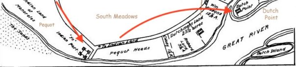
“As Sequassen’s tribe never had an opportunity to make such a collection of bloody trophies, except in the Pequot War, it seems probable and natural enough that, when he removed immediately afterwards to the South Meadow, he should dedicate this river’s bank to that purpose. So these scalps dangled from their poles in the breezes for many a day. This incident led the English to name the tract ‘Pequot Heads.’ It is now in part the land along the Connecticut River, given to the City of Hartford by Mrs. Elizabeth Colt.”

Swim.
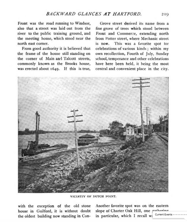
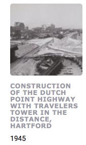
A page from the past, before highways and flood control. “In the vicinity of Dutch Point.”
Other thoughts surface. Of Samuel Colt as a boy and the original appearance of the Hartford meadows before the Colt Armory was built and the area re-shaped. Samuel and Elizabeth’s opulent home “Armsmear” (still standing, now private housing and more plain in appearance) translates into “meadow of arms” combining the industry with the setting. Stand at the hill in Colt Park and the sweeping views to the river will give an overview as to why.
Into the unknown.
An expedition vessel skirting coastlines and sailing rivers is parallel effort as getting to the moon and back safely, but without communications and a support crew network. In 1614, what was aboard. Astrolabe, accumulated knowledge from past experiences and other voyages– reading the river and weather. So, move aside time, subtract today’s human-built environment, peel back layers. Imagine. Curiosity to track Dutch Point as a place name, lead on.
(In more ways than one,) From the vantage point in the middle of Connecticut River, where the views include water, sky, woods (mostly), stepping out of time and into exploration is easy. (Not surprising that aspects of the past, such as a city’s proximity to a river and flood control are relevant to what’s happening right now.)
“In 1614 Adrian Block and Cornelius Hendricksen built a small sloop at New Amsterdam (Note: New York), as the station was called, and sailed into Long Island Sound and went up the Connecticut at least as far as the present site of Hartford. Block gave names to the rivers and bays, calling the site of New Haven ‘Rodenburgh’ or the Red Hills, and the great river, the ‘Fresh River.’ To Block Island he gave his own name. On his report to the States General, or Congress of Holland, a company was formed for trading in the New Netherlands, as the newly discovered territory was called. This company was subsequently absorbed by the Dutch East India Company. The object of the enterprise was primarily the purchase and exportation of the skins of bears, otter, mink and wildcat…”
— The Dutch in Hartford by Charles F. Johnson (text on Hartford’s Ancient Burying Ground)
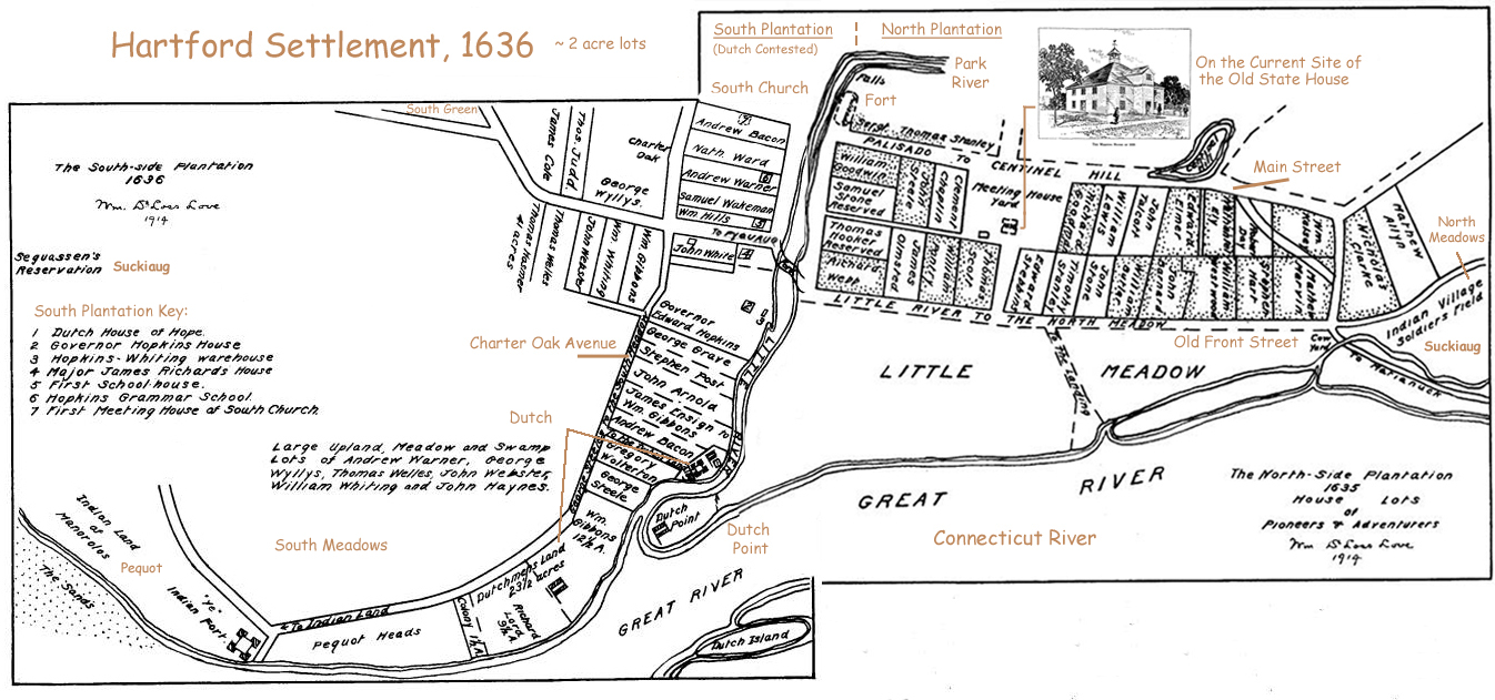
Dutch Point and Great River (linked to source, which features chronological histories and many maps) Original by William DeLoss Love.
“In 1623 these Hollanders founded a trading post at what is still known as Dutch Point, in the city of Hartford, on the north side of Little River, now known as the Park River. The original site has been largely washed away by the floods. The first establishment was no doubt a stockade or fence of stakes enclosing a rudely-built ‘block house’ or log house. By 1633 it had grown into a small fort with earthen walls (probably) enclosing several buildings and provided with a small cannon. A ship-load of bricks brought from Holland was used in the construction, and it has been suggested that the ‘fort’ was an earthwork with brick or stone corners. On the other hand the bricks may have been used for chimneys in the buildings within the enclosure. One of these Dutch bricks was found near the spot by Mr. Charles J. Hoadley, the antiquarian. Others are doubtless covered by the mud in the Connecticut River.”
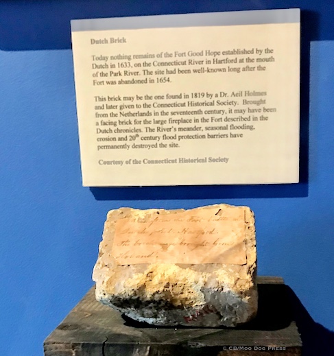
Artifact, described: Dutch Brick. “Today nothing remains of the Fort Good Hope established by the Dutch in 1633, on the Connecticut River in Hartford at the mouth of the Park River. The site had been well-known long after the Fort was abandoned in 1654.
(Yet there were people living on the land, humans who know the river, travel on it, have traditions and history. Examine the map: “To Indian Land.” That sketch includes ‘ye‘ Indian fort.)
“This brick may be the one found in 1819 by a Dr. Aeil Holmes and later given to the Connecticut Historical Society. Brought from the Netherlands in the 17th century, it may have been a facing brick for the large fireplace in the Fort described in the Dutch chronicles. The River’s meander, seasonal flooding, erosion and 20th-century flood protection barriers have permanently destroyed the site.” CHS/Connecticut River Museum
No matter as the original meadows that sloped down to the Connecticut River have all but been obliterated in the ensuing years. In the collections of University of Connecticut are black-and-white images that document the construction of the highway, bridges that stand between the city of Hartford and the Connecticut River. Thousands of vehicles stream by daily. Flood control levees and a barrier system also protect the city from damaging floodwaters, installed after the devastation that resulted from the river overflowing its banks into the city. A tributary river known by several names in its history, now flows underground.
CT Digital Archive, link.
“Most of these works were initiated in December 1938 and completed in August 1944.” — U.S. Army Corps of Engineers, New England District
Many people never even notice the buttressed system that protects human activity including transportation from the river, the city’s ever-flowing neighbor. Never more relevant and timely to consider the maintenance of all as structures age.
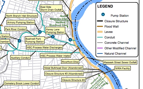
Details of a schematic map of flood control systems in Hartford by Fuss & O’Neill, 2016. Linked to the complete map (PDF).
Having seen how quickly a river can rise from its bank and invade all low-lying land, sweeping away all in its path (the Roanoke River, terrifying), an engineered system of protection in Connecticut is so appreciated.
For those who walk near rivers, major and tributary, there is almost always a natural meadow nearby that serves a natural sponge to absorb the annual cycle of spring freshets, flooding. When humans ignore that natural system, rivers still rise and fall. Those who live near rivers know this pattern and also, the location of the high water mark. Marshy areas flood; plant life will “tell” a human where the waters will permeate.
“This is editing at its extreme: writing without composing.” Annie Dillard 📖 Mornings Like These
Be here now. Twitter connects. There are giants hiding in plain sight. Do people not see?
"I think I can still write. Tell me." https://t.co/ok3bANqQBm
— Mike Pride (@HomerGlick) November 2, 2018
Life and stories. Words and more. Then. A gut punch.
Thanks, my Twitter pal. https://t.co/w3LCC6qGdE
— Mike Pride (@HomerGlick) April 16, 2023
In June, a gathering.
A memorial for my father, Charles Michael Pride, will be held Saturday, June 3, at 2 pm at St. Paul's Church, 21 Centre Street, Concord, NH. Reception to follow. Llamas will be present (per my father's request). Any and all welcome. Help get the word out. Did I mention llamas?
— Yuri Pride (@yuripridemd) April 29, 2023
"My office was at Columbia University, and Google whispered to me that a scholar by that name worked down the hall."
Mike Pride
📖 Storm Over Key West: The Civil War and the Call of Freedom. Acknowledgments.#SundaySentence https://t.co/P9mxJyzfdd pic.twitter.com/cyVauC5vYg
— Moo Dog Press (@MooDogPress) April 30, 2023