
Hidden History: Fairs, Soil, King Philip’s War + Fragments Of The Past
Reprise to remind all that our combined humanity–known as the past–is threaded into the right now.
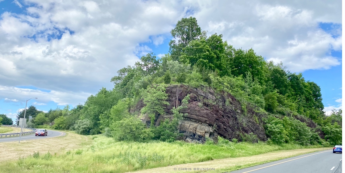
Prow of a ship, but as layers of geological time compressed. From Berlin Turnpike headed east, on the road in Connecticut.
Coming up and in progress: Fair season is going full tilt. Check out our Resources page for more. As geology and soils influence crops, livestock, health, fairs are a great place to view what makes each area different, unique. Humans were here long before Europeans immigrated to the continent. Uncovering stories and learning is for life.
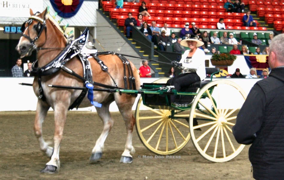
First place. Love the equine events (and the food, sights, sounds, Avenue of States) at Eastern States Exposition, The Big E. Image from a pre-pandemic fair.
“Metacomet (1638–1676) – also known as Metacom and by his adopted English name “King Philip” – was chief to the Wampanoag people and the second son of the sachem Massasoit. He became a chief in 1662 when his brother Wamsutta (or King Alexander) died….” this is a portion of what will be found online in response to a query about why a Native American sachem would be known as “King Philip.” But there is so much more to this story and his life. First of all, Massasoit is the Wampanoag chief so integral to the story (and survival) of Plymouth Plantation. Then there is controversy as to Mooanam, later called Wamsutta, first son and heir to Massasoit. He was taken by authorities for questioning, then died soon after his release – some think it was murder by poison.
For insight, read King Philip’s War: The History and Legacy of America’s Forgotten Conflict by Eric B. Schultz and Michael J. Tougias. The truth of King Philip – and horror of what happened to him – including grisly details after death – unforgettable.
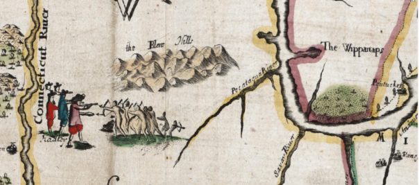
Detail of an ArcGIS map of King Philips War. Hadley is the town name written that shows under the shoes of the people to the left, but the sketch is also a visual commentary of the thoughts of the map maker. Colonists are shown in vivid color to the left; indigenous people – fighting for their lands – are depicted in pen strokes to the right. Image linked to ArcGIS map – high resolution and zoomable for seeing fine detail.
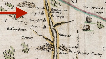
“The Connecticuts Country” (sic) – detail of the ArcGIS map. Windsor, Hartford, Wethersfield, Middletown are noted but look fairly tiny and insignificant in comparison to the indigenous populations featured on the map.
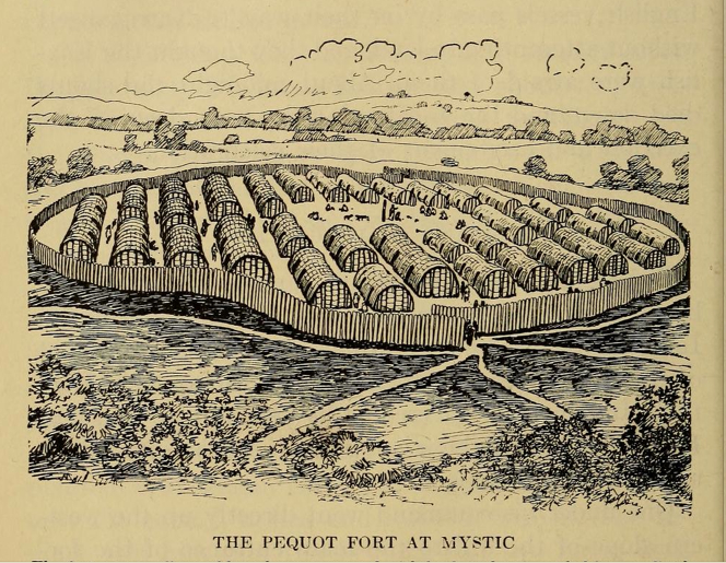
Learn about the battles between two cultures. Image is linked to Pequot War Battlefields site.
Powerful story about the meeting of two cultures, an interactive traveling exhibit. Image from “Our Story” is linked to official site.
In related news, What Lies Beneath? was the focus of a TEDxDanbury talk to “encourage us to look beyond the obvious to learn more about our world and our own lives.” One of the speakers was the late Brian Jones, CT State Archaeologist, associated with Department of Anthropology and Connecticut State Museum of Natural History at UConn, Storrs. Jones spoke of using ground penetrating radar (GPR) to “see” under the earth and discover the past at Fort Griswold, and the Hollister Farm site in Glastonbury. He mentioned that GPR is often used by cemeteries to locate burial plots and sites. This event was organized by T.J. Altieri of Danbury.
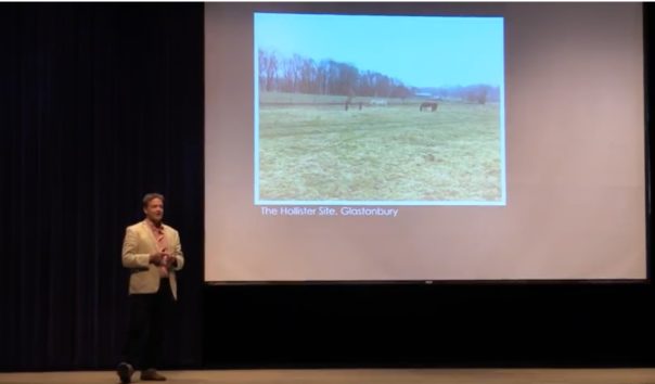
The Hollister Site in Glastonbury – a horse pasture but what lies beneath? Image from TEDxDanbury talk.
In 2022, the work at the Hollister site continues now led by Connecticut State Archaeologist Sarah Sportman. A podcast about the site and findings, with coverage and commentary by Brian Smith-Jones of ConnecticutEast, follows.
In the #podcast we talk with #Connecticuts State #Archeoogist about a 17th Century #farm complex that's the best preserved in the state. Plus other stories from across the region sponsored by @Center4HealingT https://t.co/87katHneGf#Media #reporting #journalism #history
— Connecticut East This Week (@ConnecticutEast) August 12, 2022
An excerpt about the early history of the Glastonbury-Rocky Hill Ferry Historic District, Hartford County, CT (NPS):
“Even though proprietors made use of their land on the east side of the river, the general reluctance to permanently settle in such a relatively isolated wilderness was understandable. Fresh in their memories was the 1637 massacre of nine Wethersfield settlers, the major proximate cause of the retaliatory Pequot War. Even though they grazed their cattle in the meadows and grew hill corn in the Native-American manner in the fields there, most farmers crossed the river every day to look after their farms. A few hired cattle herders, who lived in temporary quarters, or like John Hollister, employed someone to take care of their property. Settlement was delayed further by another period of unrest later in the century that culminated in King Philip’s War (1665-1667), a last ditch effort to drive Europeans out of New England, in which towns were burned and their inhabitants massacred.”
Real history. And with more than 10,000 years of human history on land and waterways known today as Connecticut – some lives left traces; many did not. Many stories wait to be told. New combinations of technology help find them and may aid in telling narratives in novel ways.
For #TectonicTuesday
Microfaults at Oldupai Gorge, Tanzania.
Bed IINotice the 'famous' "Bird Print Tuff" in the center of the pic (foot- and hanging wall) 🥰
This marker tuff anchors the Early Acheulean across the basin! #Geoscience#Archaeology pic.twitter.com/4sufEqJU7E
— Prof. Julio Mercader Florín (@ProfMercader) August 30, 2022
Professional technical help is a call away about documenting a site and what to do about finds – even if the land is being developed (the information tied to place is what will be collected and help beyond that if necessary).
Here is an excerpt Q&A of the Museum of Natural History/Connecticut Archaeology Center, the official state repository for archaeological artifacts from Connecticut and is interested in pre-historic and historic materials that will increase understanding of the past.
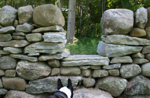
Stone wall stile. Walls and boundaries on maps are information used to “see” into the past. Structures built, pathways can leave information not always visible to the unaided eye.
What can I do to protect archaeological resources located on my property? Good stewardship begins with responsible actions. Native American sites can be very old, very fragile, and offer significant insights about the distant past. If you discover Native American artifacts, contact the Office of State Archaeology for appropriate guidance.

Found in a garden, part of a doll’s face and a glass bottle stopper.
If you occasionally find broken bits of early ceramics or other Colonial-era artifacts while gardening or landscaping, develop a system for recording or cataloging where these discoveries occurred. Draw a map of your property and describe where and how each find was discovered. This information will help future property owners, historians and archaeologists better understand the property’s changing history and use through time. However, if you discover a buried foundation or a dense concentration of historic artifacts on your property, seek the professional assistance of the Office of State Archaeology. The information of how objects are found in relation to each other may unlock more knowledge.

Lost toys may turn up near homes or in gardens.
Where can I donate my collection of artifacts? If you have materials you think might benefit this effort, and are looking for a safe, permanent home for them, contact the museum for options. Here is the link.
How can I learn more about the history of my property? Many resources exist for owners of older houses. Archival research will provide a better understanding of your house and lands. For instance, your local library, town hall, and historical society can often provide important information about the land use history of the property. A title search, old maps and atlases, tax records, government census records, and town histories may offer insights about former owners, their families and their occupations, as well as information on other structures that may have once existed on the property. Municipal historians are also highly knowledgeable and are eager to assist with research about their communities.
“Archaeologists have uncovered evidence of humans living in Southern New England as far back as 11,000 years ago, coming here right after the last glaciers melted away.”
“We have found stone tools, food middens, human remains, Colonial building foundations, the hulking remains of old industrial mills – and a host of other objects. True scientific analysis reveals a complex story about people’s changing relationship to the place they live. People seemed to have a more direct relationship with the world around them than we do today. . . . in the 21st century it almost seems like we live outside of nature. In this exhibit we explore the natural history of southern New England, how it shaped and continues to shape the lives of people who live here, and how we, in turn, have reshaped the environment,” says Emeritus State Archaeologist Nick Bellantoni in a video that is part of interactive story stations at Human’s Nature at The Connecticut State Museum of Natural History & Connecticut Archaeology Center, part of the University of Connecticut College of Liberal Arts and Sciences. Visitors are invited to digitally “meet” scientists, educators and historians who reveal what their work in geology, climatology, conservation biology, ethnobotany, and archaeology reveal about the way we live today.
Now an opportunity to see and hear stories about recent findings.
Stanton-Davis Homestead Museum (SDHM), located at the intersection of Osbrook Point Road and Greenhaven Road, is “the oldest house in Stonington, dating back to 1670. It was built by Thomas Stanton, one of the founders of Stonington- along with Thomas Miner, Walter Palmer, George Denison, and William Chesebrough. Sold in the 1760’s to the Davis family, the land remained in the Davis family for over 260 years and is recognized as the oldest continuously operating farm in Connecticut. The Homestead shares its history with the Pequot, Mohegan and Narragansett tribes. Venture Smith’s own history also has ties with this property. The last resident of the house was farmer John “Whit” Davis, who passed away in 2016 at the age of 91. Determined to preserve the historic house, Davis worked to preserve the homestead.
The late Whit Davis and a story from 2012, linked to this image.
“In 2004, a non-profit corporation was formed to preserve the Homestead, along with its contents, as a museum. The Board members of the Stanton-Davis Homestead Museum, along with a group of volunteers, have been working tirelessly to raise funds for preservation and renovation.
“The mission is to “protect, maintain, and preserve the Stanton-Davis Homestead and artifacts with the purpose of creating a museum and educational center open to the public, and dedicated to the memory of the Thomas Stanton, and Davis family, Native Americans, and African American slaves, associated with the history of the homestead-all of whom were instrumental, in the founding of Connecticut.”
“Each room of the homestead contains stories of the generations of families and individuals that have lived and worked within this home, along with ties to the broader history of our town and the state.”
Stonington history essay, stonington-ct.gov
The public is invited to a series of tours–Sept. 24 from 10 to 11 a.m.; 11:30-12:30; State Archeologist Sarah Sportman will give a peek into earlier times on the farm. And finally, on Oct. 15 from 11 a.m. to noon, a ‘Warm and Fuzzy’ Halloween Party, complete with pumpkin painting and a squash toss.
To learn more visit stanton-davishomestead.org.
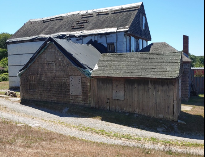
Another view. The Stanton-Davis Homestead Facebook page linked to this more recent image.
Editor’s note: A portion of this story originally appeared in 2017. More about geology in Connecticut via a DEEP PDF linked here. For those interested in how imaging technologies including satellites, drones, LiDAR, ground-penetrating radar are used/combined to search for human history and lost civilizations, here is a link to a story.